

Oman Meteorology has predicted that the direct influence of Tropical Cyclone Tej is set to commence in Dhofar and Al Wusta Governorates, starting from the evening of Sunday, October 22, 2023, bringing with it heavy rainfall in the range of 50 to 150 millimeters.
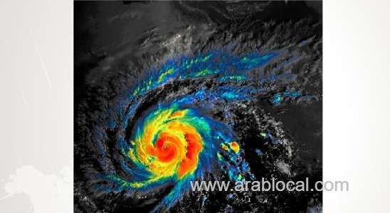
Based on the latest analysis of satellite imagery and weather charts conducted at the National Multi Hazards & Early Warning Center, it has been observed that Tropical Cyclone Tej has intensified, reaching Category 3 status. Its center is positioned at Latitude 12.3° N and Longitude 55.3° E, approximately 500 kilometers from the nearest Omani coast. Wind speeds around the center are estimated to range between 100 to 112 knots, and the nearest significant rain cloud mass is approximately 280 kilometers away from the shores of the Wilayat of Sadah.
Forecasts indicate that the system will persist in a west-northwest direction, approaching the coasts of Dhofar Governorate and the Republic of Yemen (Almahra). Furthermore, there is a likelihood of further intensification, potentially reaching Category 4 status within the next 24 hours.
The most substantial impact is anticipated on Monday and Tuesday, characterized by exceedingly heavy rainfall ranging from 200 to 500 millimeters, which may result in flash floods. Additionally, moderate to fresh winds, with speeds ranging from 40 to 70 knots, are expected, accompanied by strong gusts that could potentially lead to tree fall.
Sea conditions are predicted to be very turbulent, with wave heights spanning between 6 to 12 meters. Furthermore, storm surge effects might lead to the inundation of low-lying coastal areas with seawater.